Population: 4922 Area: 166 km2 (2016)
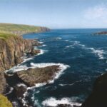
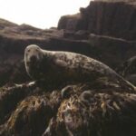
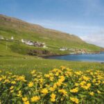
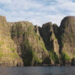
Of the 18 Faroe Islands, Suðuroy is the southernmost, as its name indicates, with its unique geology and diverse natural beauty. Sandy beaches and green slopes make up the eastern side, and surf battered majestic birdcliffs give the western side its character.
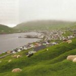
About one tenth of the Faroe population today lives in the villages and towns of the island, as people have for centuries. The South Island has its own rich history. In some places the historic records stretch back 1000 years, all the way to the Viking age.
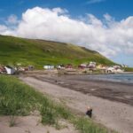
To the north on the eastern side of the island is the village of Sandvík, named after its wide sandy beach, and Hvalbøur, whose characteristics are the large beach to the east and the precipitous cliffs to the west. There are two isthmuses to the west of the village. The southern one is low
enough to permit open fishing boats in the past to take off on fishing trips and land the catches from the rich grounds west of the island. At Hvalba there are still productive coal mines. A tunnel ties these two northernmost villages together, while another tunnel connects Hvalba with Tvøroyri to the south.
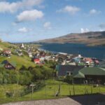
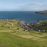
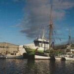
Tvøroyri, populous enough to carry the title of town, is the largest settlement on the island. When the Royal Trade Monopoly in 1836 opened a branch there, it started to grow. After Faroe was opened up to free trade in 1856, private enterprise took charge. The merchants bought disused British smacks in large numbers, and so much fish processing work was to be done at the village that people traveled there in their hundreds every spring from all over Faroe to find employment and many to settle down.
For this reason social inequalities developed there – as nowhere else in the country – between those owning capital and thereby power and a working class. This social divide created conditions for trade union activity, which got its break-through at Tvøroyri. One of its major achievements was the setting up of a TU wage office for the payment of wages in cash instead of the earlier trunk system, which tended to tie the labourers to the boat owners, merchants and fish processors.
The Great Depression of the 1930s impacted hard on Tvøroyri. Private companies went bankrupt, so individuals and trade unions joined hands to form industrial and business co-operatives. Right up until our day the trade unions and the town council have actively involved themselves in various industrial, shipping and business undertakings. The ideological polarization of the early last century still makes itself felt at Tvøroyri.
On the way to Fámjin we pass the farming village of Øravík, which was the backdrop of the old “thing” (a court for the settlement of legal disputes) in Suðuroy. Near the village road one sees a statue in memory of Johan Mortensen, the greatest entrepreneur in Faroe in the late 19th and early 20th centuries. His company, based at Tvøroyri, employed over a thousand people at sea and on land.
Fámjin is one of the two villages on the island facing west into the vast North Atlantic. The ocean surf has a free run here, but when the weather permits, Fámjin is ideally situated for fishing trips to some of the best fishing grounds off the coast. Above the village is Kirkjuvatn in all its beauty, the biggest lake on the island. In the village church hangs the first Faroe flag, Merkið, which was designed and created by a young student from Fámjin and flown for the first time in Copenhagen in 1919.
Centrally located on the island is the village of Hov (“altar”, i.e. heathen place of worship). It is an ancient settlement with its own peculiar history. There are many place names and excavated ruins of age old dwellings. At times in the past Hov was more populous than now. But improved road and tunnel connections and the construction of a central college of learning for the whole island will no doubt encourage more building there in future.
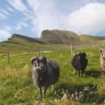
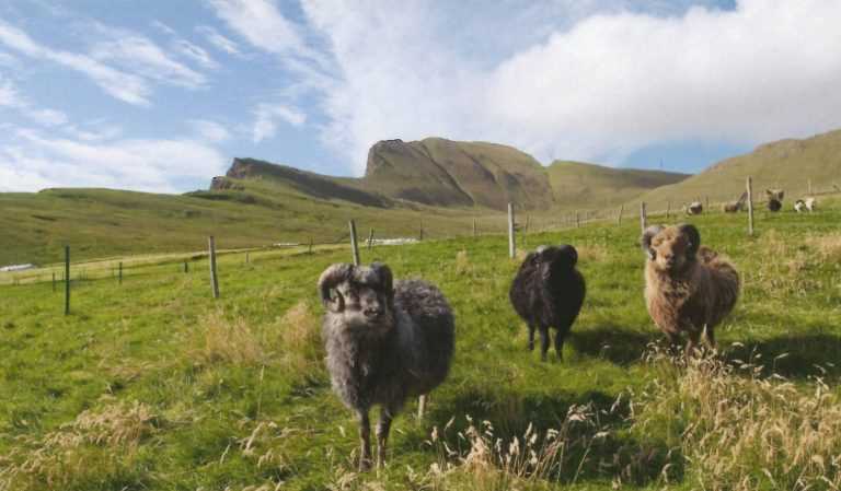
Without doing injustice to any other place it may be said that Porkeri, which we pass on our left driving south on the road to Vágur, is one of the prettiest villages in the whole country. One main reason is the carefully planned lay-out of the houses and their building style. Porkeri is an ancient settlement if not quite the age of its neighbours. As at other villages on Suðuroy fishing has been important, and the infield is so well kept and suited to home grazing of sheep. In this respect the people of Porkeri are among the foremost at breeding rams of high repute.
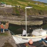
The other town in Suðuroy is Vágur. Like Tvøroyri it started growing when enterprising villagers started to buy British fishing smacks. Many people went to Vágur in search of employment and to settle down. In winter, when the fishermen were at home doing other work than fishing, dozens of smacks lay at anchor at the bottom of the bay waiting for spring. Today one of them is still in use. But not as a fishing vessel. The good sailing smack Johanna, TG 326, is now a popular part of the tourist activities Suðuroy has to offer visitors.
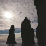
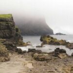
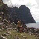
If the nature is dramatic in the north of the South Island, the southern part is no less grand. To the west there is Vágseiði with vertical Skúvanes to the south and Múlin to the north, no doubt the most photographed natural scenery in the country. From Kleivin, a sheltered natural harbour when the wind is easterly, many open rowing boats fished in days past on the rich banks west of Suðuroy. Vágur has in many respect shown the way forward as for instance being the first village in Faroe to have its own hydro-electric power station. The water came from Ryskjuvatn and rushed through the near vertical pipes down to the turbine and generators at Botnur near sea level to the north west of Vágur.
On the way to Sumba, the southernmost village in Faroe, one passes Lopra and can see Akrar. Both are small townships, but there was a time when Lopra was a centre of much industrial activity with its very busy whaling station operating several whaling boats.
A tunnel was drilled to Sumba a few years back which has made it quite easy to travel between the villages. But the old winding mountain road is still open to cars. There is quite a nature thrill to be had there as you get as close as anywhere in the world to the edge of the awesome promontory of Beinisvørð. From the mountain pass you may view most of the Faroe Islands stretched out to the north. On the way to Sumba you may visit the village of Víkarbyrgi, a now deserted little settlement with a handful of summer houses.
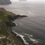
Sumba is an ancient village whose inhabitants have taken pride in preserving the age old national heritage, the traditional Faroe chain dance. The nature around Sumba is beautful and breathtaking. From Akraberg at the southern tip of the island you can see Flesjarnar and Munkin, the skerries south of Faroe proper. If people choose to sail along the island on the western side, the experience is unforgettable for the pure majesty of seeing Beinisvørð and other cliffs from below.
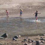
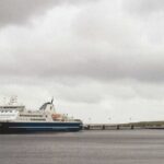
Because of the distance from the Faroe mainland to Suðuroy, the inhabitants of Suðuroy have taken steps to maintain all basic services on the island and to ensure a maximum number of jobs. The island has a lot to offer tourists who in increasing numbers visit the island. Ample and good accommodation and a variety of experiences. Tourist Information offices are at both Tvøroyri and Vágur to guide tourists and organize various activities.
In addition to primary and secondary schools Suðuroy also has third level education and a training college for nurses associated with the hospital at Tvøroyri. There are football pitches and sports halls. For entertainment and social events there are cafés, hotels, dance halls and restaurants. On an island situated at such distance from the mainland it is necessary to cater for people’s various tastes and to satisfy the requirements of its population with necessities such as jobs, amenities and social fulfillment.