Population: 22.000 Area: 392 m2
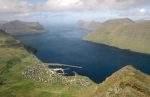
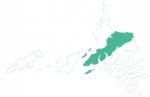
Streymoy is the biggest of the 18 Faroe Islands. It is located in the middle of the country and makes up 24% of the total land area and 45% of the whole population. Streymoy is also the most densely populated islands with 58 inhabitants per sqkm. Most live in Tórshavn.
Tórshavn — Thingstead, Trade Centre and Capital.
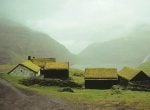
Nearly 1.200 years ago the Vikings came, and before them Irish monks, across the ocean to these isles in the north Atlantic. And if arriving by sea we can almost imagine the first settlers’ excitement when for the first time they saw the blue islands rise out of the horizon. It is still a fairy tale adventure to round Nólsoy and approach Tórshavn on the car ferry Norrøna. But the country is not the same as when the Vikings found it. People now live here who have harbours and roads; they live in small villages and towns.
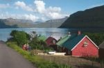
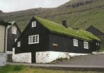
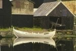
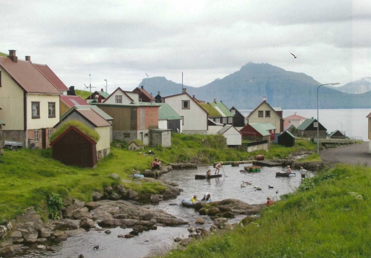
You arrive at Tórshavn located in the bay at the south eastern corner of Streymoy, the central venue of all Faroese. Dividing the busy harbour is Tinganes, the ancient thingstead. Here you find the trading place of the Middle Ages and the little historic town with the tiny tarred houses with turfed roofs. Here are the old store houses of the Royal Trade Monopoly, which today have been turned into the offices of the Prime Minister (“løgmaður”) and the central administration. The Parliament (“løgting”) has moved further uptown and now resides close to the Town Hall. Together they form the town centre, and from there the town spreads like a colourful fan up the surrounding mountain slopes.
Little is known about the first inhabitants of the Faroes, even if there is a growing interest in the Irish hermits — also among the Irish themselves. The Viking Age is described in the Saga of the Faroese, which was written a couple of centuries after the events took place. But it is exciting reading and tells at least that there was a main assembly of all free men (“alting”) at Tórshavn from the earliest times. The “thing” means that every summer the assembly at Tinganes drew people to the place to attend court meetings, to settle disputes, to trade etc. The trading company, the civil servants, the little fortress for defense against marauders have created a little but lively town. In 1609 Tórshavn got its first church, rectory, and school at Tinganes. In 1787 the church became too small, so a new one was built on the outskirts of town. Today it is the cathedral. Tórshavn grew slowly, but in 1856, when the Royal Trade Monopoly was abolished, the town was opened to incomers and started to expand, as it still does.
As capital Tórshavn is the administrative centre with the important public institutions. There are many educational options from primary school to academic, commercial, navigational, technical and teacher training colleges, which with the budding university influence the growth and social atmosphere of the town. It also has a fish processing factory and a shipyard by the western harbour and other industries in locations set aside for such purposes.
Tórshavn was a trading town and still has an intriguing choice of stores, today complimented by hotels, pubs and good restaurants.
Streymoy — the Main Island
Kirkjubøreyn bounds Tórshavn to the west. It is a rocky ridge though not any odd mountain. William Heinesen, the renowned Faroe poet who was born and grew up in Tórshavn, describes it with these words in one of his many novels from Tórshavn; “[B]ehind this slope one could discern the barren stone desert, Kirkjubøreyn, where Cain and Abel had their altars, and where later Noah’s ark stranded and Moses fetched the tables of the law. One later got the chance to see at close quarters fragments of these broken tables. They are still scattered up there if anybody should be interested, together with fossilised wreckage of the animals of the ark amidst red ashes from the fires of the thank-offering. And among gigantic moss-grown mounds of rock there are ferns left behind and junipers from the disused Garden of Eden.”
Kirkjubøur
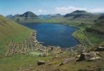
But Streymoy is much more than Tórshavn. On the southern point is Kirkjubøur, the cultural and ecclesiastic centre of the Middle Ages until the Reformation around 1560. When one keeps in mind that the land has sunk almost 3 metres at this point over the past 1000 years, and that the islet off Kirkjubøur was part of the mainland, it is easier to imagine the village with wealthy farms, the bishop’s estate and the three churches. Today the royal farmstead with the medieval log cabin rests on the foundation of the episcopal farm. The Saint Olav’s Church is the oldest parish church in Faroe and at the southern end there is the impressive Sct. Magnus Cathedral, the most significant historic site in Faroe.
From Kirkjubøur one has a view of Hestur and Koltur, two small islands, each well worth a visit. There are daily ferry links with Hestur, but one needs to take the helicopter to visit Koltur, where only one family resides.
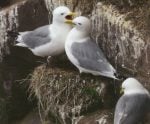
Nólsoy to the east of Tórshavn and sheltering the capital from the south and easterly winds is also one of the smaller isles with only one village. At the present time when people move from the small islands to the mainland, it makes one happy to ascertain that the village of Nolsoy is growing and prepares for further expansion. The island is rich in historic and ancient sites besides having a rich bird life. There one also finds the world’s biggest nesting colony of petrels.
Streams and Tides
Streymoy is surrounded by tide swept narrows and sounds. Towards Eysturoy on the east side are Sundini. When standing on the bridge connecting the two islands you can observe the current running north or south depending on the tide. The current can be so rapid that it forms a small waterfall among the bridge
pillars. To the west Hestfjørður separates Streymoy from Hestur and Koltur. Further to the north Vestmannasund divides Streymoy from Vágoy. When one observes the eddies which arise when the tide changes, one understands why it was vital to know intimately the tidal currents and how they run at the time when people depended upon rowing and sailing when traveling between the islands or going out to fish. Even in our day and age the ferries navigate according to the tides and currents.
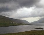
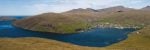
Streymoy is very diversified naturally. The coast to the west and north consists of almost precipitous birdcliffs. The landscape is wild and deserted, while the south and east coasts are more open with deep fiords and settlements which grew up around the estuaries at the bottom of the fiords. Inland there are high mountains, deep vales, lakes and streams.
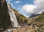
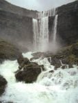
The streams are a fantastic part of Faroe nature. They are everywhere in all shapes and sizes, from small springs to wide meandering rivers and pretty cataracts.
The most intriguing and surprising aspect of the streams is how they change. They depend on the precipitation, and during a rainless period they quickly dry up. Alternately it doesn’t take more than a rainy day or night for them to fill up, so that the little inconspicuous brook turns into at raging torrent. Kaldbaksfjørður, by far the most magnificent as regards rivers, is one day a calm fiord with barely trickling riverbeds and the next day an endless row of waterfalls cascading over the layers of rocky formations.
The wind can also interfere with the grand sight and blow the water the opposite way, so the rivers almost run upwards, while the whirlwinds on the fiord send the sea water spinning up in the air.
Varying Landscape
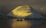
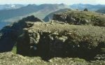
Upon leaving Tórshavn heading north along the mountain road one gets a fantastic view of the sea and landscape below and of Sornfelli and Skælingsfjall above. The latter was long thought to be the highest peak in Faroe. It rises 767 metres, and even though it is not the highest mountain, it is an impressive sight whether seen from Kollafjørður below or across from Vágar. Winding around Skælingsfjall is Streymoyar Sillin, a strange landscape of volcanic intrusion and eroded by the ice. If one beholds Sillin from above, it looks like a gigantic gigsaw puzzle, and from the side one is impressed by the enormous basalt columns.
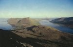
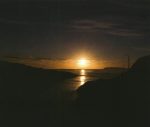
It is an old custom on the longest day of the year to walk up to the top of Skæling to see the sun setting and rising again a couple of hours later. The waiting time people spent dancing the Faroe ring dance to keep warm in the meantime. From the top one can see all the islands in clear weather. If one doesn’ t like hights, one may instead walk west of Sornfelli and down south again to Norðradalur. The hike is not tiring and one is richly rewarded by the breath-taking sight of Vágoy to the west. After that one sees Koltur, Flestoy and Sandoy. And in reasonably clear weather there is also a view of all the southern islands.
North of Skæling and Satan in the valley between Kollafjørður and Leynar are the lakes of Leynavatn and Mjáuvøtn. They are good for salmon and trout fishing. In August one may see the salmon anglers standing all the way around the lakes, no matter the weather, absorbed in their salmon fishing. To assist nature and the salmon they have constructed a salmon ladder in the river running from the lakes through the village of Leynar down to the beach. The Leynar Beach is also quite unique. The Faroes are not endowed with many white sand beaches, but as soon as the sun shines in summer, Leynar Beach is as tightly packed with sun bathers as the beaches of the Riviera.
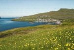
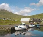
West of Leynar is Kvívík, a pic- toresque village. Kvívík is located in a deep valley with steep sides. Behind the village Egilsfjall towers, and the stream runs wide and watery through the village down to the sea. By the harbour lies the church and the vicarage and the characteristic boat houses. In Kvívík they have some years ago excavated a Viking farm. The southern end of the farmhouse had been washed away by the surf, and the ruins are so close to the sea that they show how much the shore has changed since the farm was built.
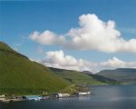
Vestmanna is Streymoy’s biggest village after Tórshavn. It is situated at a wide bay and surrounded by high mountains. It is sheltered and often has higher temperatures than other places in Faroe. But precipitation is also high in a band from Vestmanna to Hvalvík on the east side of Streymoy. The rivers here used to be magnificent. People have built big water dams up in the valleys and major power stations at Vestmanna. Some years ago windmills were erected in one of the valleys, which can now supplement water with wind power.
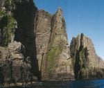
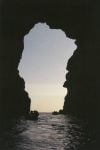
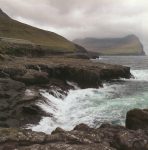
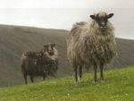
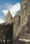
The towering birdcliffs north of Vestmanna are one of the most famous tourist targets. It is a breath-taking experience to sail by boat along the coast to the bird- cliffs rising over 600 metres above sea level. It is a rugged foreshore with free standing rock formations, deep ravines and caves. It gives one a sinking feeling when the boat sails into the dark and emerges on the other side. When one looks up at the grassy gradients near the top, it is surprising how the sheep manage to balance on the near precipitous slopes. The many birds and perhaps also seals make the experience even greater.
Between Vestmanna and Saksun there are Dalarnir (The Valleys), an unpopulated and impressive landscape with streams, lakes and valleys surrounded by high mountains. Here one may wander for you have the opportunity, for the boat still sails the old mail route among the northern isles, and it runs faithfully back and forth in summer and winter in all sorts of weather, every day and sometimes twice a day. Much to the surprise of the locals and perhaps even more so to the crew their boat has become famous.
For them it is part of daily life and at times a trying experience with rough weather, strong currents and choppy waves, while other travelers in Faroe may sit down in a cosy bus and reach their destinations in minutes. But the old sea mail route is described in “Lonely Planet” as unique in the world and no doubt one of the most thrilling experiences for any traveler.
The Seal Woman and the Sea Birds
Coming from the south, the first northern island is Kalsoy. The island has got the nickname “the flute” because of the tunnels connecting the four villages. You reach Kalsoy by ferry. “Sam” sails from Klaksvík to Húsar. The bus trip from Húsar to Trøllanes goes through four pitch dark and narrow tunnels. But don’t worry. The bus driver has done the trip at least a thousand times, and he will take you safely through, i.a. through the village of Mikla- dalur, which is well known as a motif in many Faroe paintings, as many painters were born and grew up there.
Many legends are associated with Kalsoy. The best known one is the fairy-tale of the Seal Woman, who was forced to marry a farmer’s son from Mikladalur and had children with him. But all the time she longed back to the sea. One day when her husband was out fishing, he had forgotten to take with him the key to the chest inside which her sealskin was locked. The Seal Woman found it, put on the hide and returned to the sea.
The Bird Island and the ” Pig” Island
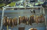
But back to the other mail boat,”Másin”. It sails from Hvannasund, the village by the narrow sound between Borðoy and Viðoy, out to the islands to the northeast, Fugloy and Svínoy, a voyage which may be described as the most magnificent of all in Faroe. Lean back and enjoy the sight of all the busy sea birds flying back and forth with food for their nestlings, amongst them the puffin which may carry as many as 20 herrings in its beak at a time. Flow it can take one more fish without losing the others is still at riddle to many.
It is easy to understand how Fugloy, the Bird Isle, has got its name. It gets a bit more difficult with Svínoy, for there are no pigs in Faroe. But at one time swine were bred here, and it is said that Svínoy was originally a floating island drifting about and it didn’t get stuck until a woman from Viðareiði had the idea of tying a key ring to the tail of a sow and letting it swim out on to the island. Thus the island was fixed, tied by the metal of the ring. Out on these islands one may still meet people who live in perfect harmony with nature. Don’t think their reservation is due to shyness. You have come to them and only stay for a moment. They have been here always, and their time reckoning doesn’t follow the normal work day from 9 till 5.
The World´s Highest Promontory
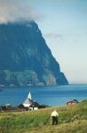
But modern times are not far removed. In Klaksvík the visitors who prefer driving to sailing may catch the bus to Viðareiði in the north. The rectory there is the most charming of its kind in Faroe. Here Beinta, the minister’s wife who became the main character in Jørgen Frantz Jacobsen’s novel, Barbara, lived for at time. Viðareiði is the starting point of hikes to the northern tip of the island, Enniberg, the highest promontory in Europe (and probably in the world). One may spend the night at Viðareiði at the comfortable Hotel Norð.
The isle of Kunoy can also be reached by bus from Klaksvík. Kunoy is on average the highest island in Faroe, and the township on the western side is well known for its lovely location with views to the west and north across to Kalsoy. The sunset here on a summer night is something quite on its own.
The Town with the Submerged Road
In April 2006 the North Islands Tunnel was opened between Klaksvík and Leirvík on the island of Eysturoy, where a ferry operated earlier. So it is possible to drive in one stretch between Tórshavn and Klaksvík.
The natural scenery is overwhelming and the peace all-pervading. But it is the busy and pulsating town of Klaksvík, the centre of the Northern Isles, where all visits begin and end.
Klaksvík has relics right from the Viking Age, while its recent history is short and hectic. On the eastern side of Borðoyarvík there are ruins of a farm which on March 12 in 1745 and the same date in 1765 was buried by avalanches. Further out there are íslendingatoftir with some excavated Viking ruins.
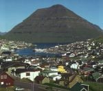
In 1838 the Royal Trade Monopoly set up a branch here, and Klaksvík was in 1908 granted official status as a winter anchor age for sea-going vessels. It made many skippers and their crews settle down here permanently. Thus began the development which has made Klaksvík the most important fishery town in Faroe.
Klaksvík is the “capital” of the Northern Isles with all the facilities one may expect of a town. It is important for Faroe production and its economy. It also plays a role as a centre of modern art. In August the Summer Festival is held here — one of the music festivals in Faroe — and attracts between 8 and 10.000 listeners over a weekend.
Of places of particular tourist interest Christianskirkjan is a must. This magnificent church structure stood completed in 1963 and has i.a. a baptismal font which originally was a 4000 year old heathen drinking bowl from Denmark.
Besides all kinds of fish related products Klaksvík also produces beer. The biggest brewery in Faroe, Føroya Bjór, is domiciled in Klaksvík.
It is the second biggest town in Faroe and it is the fishery capital of the islands. The municipality encompasses the villages of Arna- fjørður, Norðoyri and Anirnar. In all about 4.800 people live here.
A Round Trip on the Island
Eysturoy varies much in appearance. Mountains and valleys lie side by side, to the south with a rolling hilly landscape and to the north with steeper and higher mountains. Runavík, the biggest town of the island, is located by Skálafjørður.
Further south, around the lake of Toftåvatn, we find low rolling hills with the widest stretches of heather in the country. At Nes we see the old Dean’s farm and the old Nes church, one of the five old wooden churches in Eysturoy built in the early 19th century. A short distance from there is the stately Frederik’s Church, now the official parish church.
Guarding threateningly the entry to the fiord sits a huge gun from WW II. It is said to originate from the battleship the “mighty” Hood.
Runavík has much to offer visitors, and in the part of it called Glyvrar is the museum “Forni”.
Further in along the fiord we get to Skipanes, where the Viking chieftain at Gøta, Tróndur, according to the saga had his ships beached in winter.
Near the inner end of the fiord one passes beneath Valaknúkar, where the refractory “Floksmenn” in the late Middle Ages were pushed over the cliff and executed.
Then we arrive at Skála- botnur, where the biggest free church, Keldan, has recently been built.
Milium Fjarða — the stretch of road between Skálafjørður and the Eysturoy tunnel — we find the mound where the inhabitants of Eysturoy held their “thing” in the days of old. The mound is called Stevnuválur, which means “the place where people gather.”
Turning right from the road Milium Fjarða the road that leads upwards take us to the two villages of Hellur and Oyndarfjørður, situated by a very attractive bay facing Djúpini, the sound separating Eysturoy and Kalsoy. Both villages play a part in the legends, and at Oyndarfjørður the main attraction is a strange natural phenomenon called Rinkusteinar: They are two gigantic stones which since time immemorial have stood rocking (hence their name) in the sea a few metres from the shore. It may be difficult to explain scientifically this eternal clock work, but luckily village legend tells the story behind the “Rocking Stones.” They are two pirate ships which an old woman once bewitched to save the village from an unwanted attack of brigands.
Oyndarfjørður was also once the domicile of the Dean of the Faroes. He resided at Garðshorn. The village church is also one of the well known wooden churches of the island. It stands out because of its white colour, and inside there is the beautiful altarpiece painted by the famous Danish painter C. W. Eckersberg.
At Hellur there is a chapel decorated with a pretty relief with folkloristic motifs created by the multi-artist in Fuglafjørður, Frits Johannesen.
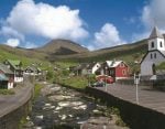
Elduvík, Funningsfjørður and Funningur are well worth a visit, where the traveller can form an opinion on how Faroe village were traditionally laid out. The houses stand as if they had been dropped from the sky and found their place by chance. The result is a cosy variety of yards, paths, steps and ledges, where people not yet caught up in the straightness of today can find pleasure.
From Funningur we may drive up the steep winding road beneath our highest mountain, Slættara- tindur, over the pass to Gjógv, and through the long valley down to yet another cosy village brimming with a comfy atmosphere and grand landscape on all sides, where one senses the contrast between the steep and the widespread surroundings. Here one finds the most breathtaking natural harbour in the country, the Gorge, which has given Gjógv its name. You walk down endless steps into the ravine.
Next to the steps there are “lun- nar”, wooden crossbeams used to pull open boats down to the water and up again. At the bottom the enormous rock forms a ceiling over the concrete jetty, where the men used to sit and make the gear ready for the fishing trips. The villagers at Gjógv will tell you that in winter storms the surf will fill the gorge and even spill over into the village. But on a clement summer day this is one of the most attractively and spell-binding places in the whole country. Down at the water’s edge one may watch the “Iceland Stairs”. A stone formation which looks like a stairwell down to the bottom of the ocean. According to folk legend it stretches all the way to Iceland.
From Gjógv one may drive back up towards Slættaratindur, the highest peak in Faroe and down to the village of Eiði. On the left is Ovara (Upper) Eiðisvatn, which has recently had its water level raised considerably by means of two damns. This is one of our most important hydro electric reservoires.
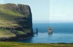
To the right there are the two marvellous stone formations out in the sea, “Risin” and “Kellingin” (The Ogre and the Witch) These two must have been the first tourists in Faroe! Legend has it that two giants came wading from Iceland to Faroe and liked the islands so much that they wanted to take them back to Iceland. The giant asked his wife to lay her rope around the promontory of Eiðiskollur, and then he should pull. But unfortunately for them the mountain top broke under the strain. The female ogre tried again, and her husband pulled with all his weight. They toiled and sweated , but forgot to keep an eye on the dawn. When the sun rose over the horizon, the two busy giants turned into rock. That’s what happens to infernal creatures when God’s light strikes them! And there they still stand as “living” proof that the first tourists in Faroe chose Eysturoy of all the islands, and that they were also “graced” with a couple of sun rays during their stay!
The church at Eiði is a proud stone structure and was in the 1880s regarded as one of the prettiest in the Kingdom. Eiði has long been considered one of the biggest and best townships in Eysturoy. Here lived great visionaries, who early in our recent history went abroad. The farmer at the Látrið farm built a mansion comparable to the official residences in Tórshavn. The house was visited by several royal persons, and the farmer was familiar with the polished floors in Copenhagen. The house Látrið is still there, today as a museum with many interesting relics.
The drive south along the west side of Eysturoy is attractive, in particular in the afternoon when the sun rays come from the west (“vesturskin” that is called in Faroese). Rows of rock, ravines and waterfalls surround the traveler, and the narrows between Eysturoy and Streymoy remind one more of a river than the sea. Across on the Streymoy side one sees small grassy patches rising in steps up the slopes, as our forefathers toiled to guard their tilled soil against erosion.
Further south on the west side of the island lies Selatrað. An ancient township, which in addition to its history has the most peculiar rock formations, i.a. the alluring basalt columns at Hagagjógv.
On the east side of Eysturoy there are — in addition to the heather around Toftavatn — large tracts of infield and outfield around the villages of Æðuvík and Rituvík. From these townships it is easy to hike along the much used paths to Nes and Lamba with their well kept cairns. In historic Lamba the “Løgmaður” (lit. “lawman”, head of the council and court) had his farm at one time. In this village they still mention the drama when the Nordic Lion, the good ship of the Danish East India Company, was wrecked near the village one stormy night in 1707.
At Gøta history goes right back to the Viking age. This was the seat of Tróndur í Gøta, the mighty chieftain whose estate covered half of Eysturoy all of Kallsoy. Not exactly an indigent peasant! Tróndur plays a major role in the Saga of the Faroese, in which he is described as both wise and clever by those who for better or worse dealt with him. That he was a man of note is doubtless…even though we may question the sagas as sources of historic ‘uth. At Gøta people are in n< doubt that Tróndur was a powrful man, and at the old church, just next to the museum Blásastovachey point out his abode Tróndar Grund. This is where Tróndur lived more than 1000 year back. Blástova and the old church at Norðigøta are both part of the village museum. But also the new churclat Gøtugjógv has become an attraction. It is adorned with map mosaics of glass art by Tróndudatursson.
Between Gøta ad Leirvík we find a walking pai which has been in use for many centuries and trodden by most pole who traveled between the wo villages. Cairns show the wap snowy and foggy weather, and god steps and rails have been constructed at the steepest sections. Upon the mountain we come across a shelter — Fransaflóttur — where the inhabitants of Gøta sought refuge when they heard news of suspicious hostile ships among the islands.
At Leirvík ruins were uncovered a few years ago which proved to hail back to Viking times. These remains are today restored so one may see how the Norse settlers placed their living quarters, their outhouses and stables. At Leirvík there is a museum with many works of art by the well known impressionist Jóannis Kristiansen and in the same building a fine boat museum, showing how the Faroese fished from times immemorial up until WW II.
The old village road through the mountain side north of Leirvík is narrow, but intriguing as it runs along this steep gradient. At Varmakeldueiði one turns right on to the new road to Fuglafjørður.
Below Varmakeldueiði near sea level there is a warm spring called Varmakelda. Its water is always about 18o C warm and has been so for centuries. In the past people thought this spring held mystic powers to heal illnesses and is still today visited by many, though the faith in its magic qualities has weakened. According to custom people visited the spring at old Midsummer night (between 3rd and 4th of July), for then its healing powers were at their strongest. Then people danced on the rocky surface near the spring.
Fuglafjørður is an ancient settlement. In the 1950s people found traces of an old farmstead Niðri við Gjógvará. When they excavated it, they found a great deal of artifacts and foundations of old houses from the earliest times. The eldest dated back to the 9th century, so it is likely that all three villages, Fuglafjørður, Gøta and Leirvík were settled at about the same time. At Fuglafjørður one may experience both old and new. In the town two old houses have been restored, and the old stone-walled school from 1882 is now Tourist Information office and library, and the oldest store is both a knitwear outlet and an art gallery. The old Sjúrðargøta (Sjúrður’s Path), where the cairns guide hikers to the northern villages, is still much used by the locals and visitors. Visits are also popular up to Gjógvaráfjall, where the ruins of t e old shelter, Uppi í Fdúsi, reminds us of the times when people fled enemy mauraders.
All that i mentioned above about Eysturoy, the second biggest island in Faroe, makes it no wonder that the first “tourists” from Iceland chose to bring this island back home with them after their visit in “giant monolithic” times.
A few year back a Faroese with an Icelandic wife put their little son to bed. He used to tell his son stories to make him drowsy. This night the father told his son about the Giant ad the Witch. When he had finished the story and was tiptoeing towards the door, the son asked quietly, “Dad, don’t you think it a pity that the sun rose?”
The father had to agree with his son, went out into the sitting- room and rote the sweet story: “Pity the sun rose.” Needless to say this story became a bestseller.