The Plumber who became the Award-Winning Photographer, Steinipíp
Þorstein Ásgeirsson started travelling the Highlands with the legendary Guðmundur Jónasson at the age of eleven
Award-winning photographer, Þorsteinn Ásgeirsson [b. 1952], at the age of eleven, started travelling Iceland’s majestic Highlands, the largest undeveloped area in all of Europe, covering some 40,000 square kilometres of Arctic desert, glaciers, rivers, waterfalls, geothermals and mountains. They are a point of pride for many Icelanders. It was during the early sixties. Þorsteinn had the best possible teacher in Iceland’s legendary bus-driver and highland-explorer, Guðmundur Jónasson [1909-1985] from Múla in Húnavatnssýsla – Bearcub Water County – in the North. The youth listened intently to his teacher telling stories of the land and its people. He bought his first camera and started photographing at early age.
Þorsteinn Ásgeirsson AKA Steinipíp
In one of his first travels with the grand old man, they went to the amazing Landmannalaugar – Land-Men Warm Pools. The young man would listen intently to how the first generations of Settlers would herd sheep into the mountains for the summer and that Landmannalaugar was then already a meeting place. He learnt of Hattver at Jökulgil – Hat Place at Glacier Ravine – deep in Landmannalaugar, where Torfi (the rich) Jónsson from Klofi in Landsveit sought shelter from the Plague in the late 15th century. Close by is Frostastaðavatn – Freezing Place Lake. Late into the 19th century or even 20th century, people would be wary of the útilegumenn – Outlaws, who were claimed to live in the Highlands.
It is fun to travel in the Highlands, explore them and get to know their history a little better. All roads should be preserved and used; they have become monuments and have significant cultural value. Folktales from the turn of the 20th century say that the Landmenn and Skaftfellingar quarrelled. They considered each other to be outlaws if they were seen in Veiðivötn, and it happened that the two groups fought, even with guns. I suspect, however, that they were only fetching trout in Lake Veiðivötn. There was a strong belief in outlaws at the time. If someone was seen in the Highlands, it was generally thought that the person in question was either a sheep thief or an outlaw. Today they are called ‘off-road good-for-nothings’.
Neil Armstrong & Sir Edmund Hillary
When NASA chose Iceland as their training ground for the first moon landing in July 1969, due to its lunar style landscape, Guðmundur was chosen to take them into the Highlands. It was 1965 when he met with Captain Neil Armstrong [1930-2012] and his fellow astronauts. The young teen followed the news intently since, for obvious reasons, he was not allowed to accompany them. Armstrong’s words on the Moon would travel the world: “One small step for man, one giant leap for mankind.” When Sir Edmund Hillary [1919-2008] had visited Iceland back in 1954, Guðmundur had guided Sir Edmund, who had climbed Mount Everest the year before. Such was Guðmundur’s status as a true legend, the world’s trailblazers would meet him when visiting Iceland.
From the source of Blákvísl Stream, we continue on Öldufellsleið road. There we come to Blákvíslarfoss Waterfall, where we cross the waterfall’s edge. If you are driving towards Mýrdalur, go down a small road that turns below the stream. You really can’t skip this slight detour because the waterfall is magnificent, and the water is cold and tasty. When travellers have enjoyed the beauty of the waterfall, they continue along the cliff’s edge. Not far away, you can see Hafursey and even drive around it. Nearby Þakgil should not be missed.
Punched the great man in the nose
“I learnt a lot from that great man. I’ve often wondered why we became such good friends; I, a teenager and Guðmundur, a seasoned legend. I remember him picking me up by my ears. It was quite common at the time that grown-ups would do such things. I was twelve and it hurt so I punched him in the nose. I believe that was when our friendship got stronger”, Þorsteinn Ásgeirsson says, smiling in the interview with the Icelandic Times. “The majesty and the freedoms of the Highlands would draw me again and again to the bounteous and serene wild. I became a pípulagningamaður – pipe laying man or plumber – known as Steinipíp, butmy passion was exploring the Highlands with my camera in hand”, he continues. Steinipíp – Stone pipe – has become his artist’s name. Steinipíp feels that there are dark skies on the horizon, as the Highlands are in danger of being run by all-controlling autocrats, using sweet-talk to hide their true intentions.
Öldudadlsleið is real eye candy and a unique experience, and you can only find a similar experience in the Highlands. Botnjökull Glacier is on the right in the picture. Öldufell is in the middle of the photo and the source of Bláfjallakvísl Stream, Mt. Bláfjöll is to its left. Torfajökull Glacier is a bit to the north. This place is connected to Torfi í Klofa (a figure in Icelandic history). It is said that he travelled the area with an abducted girl. Her cousin gave chase and followed them, and it is said that Torfi had no choice but to jump over the narrowest part of the gorge to escape, which he did. However, the girl’s cousin did not make the jump and hung on a small tree on the gorge’s edge. The girl asked Torfi to cut down the small tree, but he decided to save the man. They then reconciled wholeheartedly and Torfi got his girl. Place names that are said to be named after Torfi are: Torfajökull, Torfatindur, Torfamýri, Torfafit and Torfavatn. Blesamýri and Faxi are said to be named after his horses.
National Highland Park
The government of 2017-2021 wanted to make the Highlands a national park, with the stated goal of improving and strengthening Iceland’s image as a nation supporting the preservation of pristine land and wildlife for the benefit of those who visit Iceland; a sanctuary for those who wish to enjoy the natural environment of the central highland, take pleasure in outdoor activities and relish experience of nature. Many feel that this is meaningless sweettalk hiding a takeover. Establishment of national park is being advocated by the far Left-Green party, formerly the Communists. Those who oppose it have been called “a whining minority” by former Parliamentary Speaker, Steingrímur J. Sigfússon, the founder of Vinstri-græn, or Vg as the Left- Green party is referred to.
Mælifell in Mælifellssandur Desert is in the middle of the picture. Mælifell is a good landmark and can be seen from far away. Right next to the mountain is a stream called Brennivínskvísl Stream. Its name is considered a good reason to have a shot or two of Brennivín while resting tired bones before a continued journey. It is said that Brennvínskvísl got its name when Bishop Þorlákur went there with an entourage. When they arrived at the stream, the men dismounted, and Þorlákur picked up a small flask of Brennivín and said: “You see, boys, that the wine does not kill us on the mountain”. Then they all drank from the flask. It’s hard to travel across the Mælifellssandur Desert in the first half of the summer due to flooding. It is hardly passable until the middle of July. I was there on a trip with my friends in perfect weather and the state of the roads was optimal. However, we decided to drink coffee and have a fun chat instead of Brennivín when we arrived at Brennivínskvíls Stream.
However, Icelanders who have travelled and enjoyed the freedoms of the Highlands for decades are sceptical and have put up concerted criticism of the plan. They are putting up a fight against the State taking over the Highlands and, many feel, basically everything in the country. They feel that the signs are there already, controlling bureaucrats, overreaching their powers. The establishment of the national park was met with heavy resistance in Parliament and the plans did not go through before the Parliamentary Elections in September.
Skælingar’s environment is unique, like nature’s amusement park. To get there, drive to Nyrðri-Ófæra just east of Eldgjá and up the eastern edge of Eldgjá along the road to Gjátindur. Soon after reaching the edge, there is an intersection to drive down a slope towards Skaftá. Follow the path that leads to the hut. If you continue from Skælingar up to Langasjór, you drive about one kilometre in the water at Blautulón lake. Drivers must take care because the lake is deep, so keep as close to the bank as possible. This route is more difficult and needs to be travelled on well-equipped jeeps. You should not drive the Blautulón route on unmodified jeeps. This route is well worth taking, though.
Municipalities, not a paralyzing State
Steinipíp is highly critical of plans for a Highland National Park. He says that he has met with landverði – land-guards – overreaching and abusing their powers. Steinipíp has written on the issue and warned against the State taking over the Highlands. “It is absurd that people can’t travel the Highlands without having controlling guards policing all over the place. It goes against the very nature and freedoms of the Highlands. The all-controlling Left wants to take over the country and the Highlands included. People have to be wary of their intentions. It is a much better solution that the Highlands are administrated by the many municipalities involved and have an interest in promoting their local treasures such as Landmannalaugar, instead of an all-engulfing, paralyzing State, the municipalities with invested interest would ensure respect for our national treasures, promote competition and divide power”, Steinipíp claims. -HH
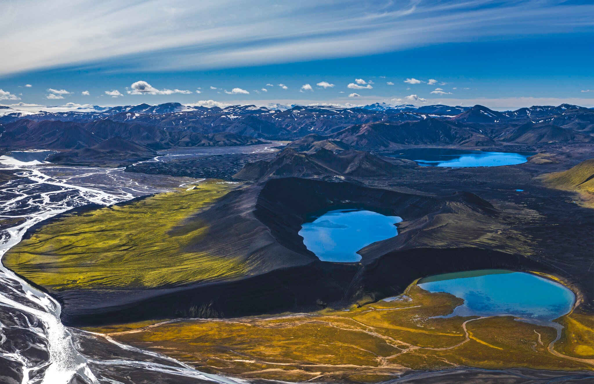
When I first visited Skælingar, I was fascinated by the place. You can find these unique lava formations in other areas, and it is always worth stopping and taking pictures. The lava formations formed when lava flowed from Eldgjá. Blockages formed in the lava flow, and a large amount of lava then accumulated in ponds. Usually, the blockages break away reasonably quickly. In Skælingar, the clogs have cooled quicker than the lava in the pond, probably due to accumulations with a different coagulation process. These lava plugs remained, but the lava from the pond continued to flow.This photo was taken with a drone over Langisjór, with the permission of Vatnajökull National Park. Up along the middle of the picture by Langasjór are Fögrufjöll mountains which end in the Vatnajökull Glacier. You can also see the Skaftá River flowing past Fögrufjöll. Farthest to the right on Vatnajökull Glacier, you can see Grímsfjall. To the left of the picture, there is a mountain range by the water. Breiðbakur towers the highest there, but it is possible to drive there. Next, Niðri- and Syðri- Hágöngur can be seen, which are prominent in many parts of the Highlands. Bárðarbunga can be seen in the picture. A plane named ‘Geysir’ was forced to had to make an emergency landing on the sloping top of the Vatnajökull Glacier. The story goes that the landing was so soft that the passengers did not feel anything and had no idea they had landed. My father was one of the rescued people, and he said that he lost 7 kilos during that trip. He also told me that there was gold in the plane he picked up. Later I got a pod camera found in Geysir; from then on, I started taking pictures.Few places compare to Tungnaá River in beauty. The photo was taken with a drone in a southwesterly direction. The picture shows Hekla towering in the far right. To the west, smoke (like snow) can be seen in the mountains, the Landmannalaugar pools are located there. The mountain ridge called Barmur stretches from there, and then to the far left is the Torfajökull Glacier area. Then there is Ljótipollur Lake (Ugly Pond), correctly named, and Frostastaðavatn Lake, a little further to the right. Frostastaðavatn is probably the most photographed lake in the highlands. It is unsurprising since the area is breathtakingly beautiful.The picture is taken above a series of craters called Lakagígar and ends in a tuff mountain called Laki. It is not known if the craters in the crater series have separate names. But I have been told that locals know what many craters are called. One is called Tjarnargígur, for instance. Lakagígar is a series of craters on a 25 km long eruption fissure west of Vatnajökull Glacier. The series of craters is named after an old tuff mountain called Laki and is close to the middle of the picture. Lakagígar was protected in 1971, but the area was created in Skaftáreldur in 1783-1784, one of the largest eruptions in Icelandic history. Previously, the series of craters was called Eldborgir. The eruption of Lakagígar began on Whit Sunday, June 8, 1783, following a series of earthquakes. Lakagígar lies on ten parallel cracks, each 2-5 km long. At the southern end of the crater series by the Hnúta mountain, the first crack opened. Then started a wave of eruptions that all began with earthquakes. The eruption formed about 135 craters and a 2-500-metre-wide rift valley from the roots of Laki and reached two kilometres southwest of it. Ash and volcanic fumes caused a thick fog and mist over Iceland, spreading over Europe, Asia and America. Heavy pollution accompanied the mist that caused poisoning to the vegetation, so almost half of all livestock perished in Iceland, leading to famine among the people. The mist and eruptions also caused cold weather because they reduced the sun’s radiation and dimmed the sunshine. These were the so-called Mist-hardships, the greatest hardships that have befallen Icelanders. The eruption is one of the most devastating eruptions in human history. The lava from Lakagígar covers about 600 km².One of the most amazing places in the Fjallabakarea is the Rauðibotn crater: a red and green emerald surrounded by volcanic deserts between Torfajökull and Mýrdalsjökull glaciers. Rauðibotn is more spectacular, seen from the Hólmsá river and its waterfalls. Rauðibotn is part of a chain of volcanic craters that stretches through the central highlands from Mýrdalsjökull to Vatnajökull glaciers. The volcano is connected to the Katla volcano, where both are part of the same volcanic system. The volcano has only erupted once since the Settlement. In the 10th century or more precisely in 934, Eldgjá erupted. It is the largest eruption in Iceland in recent millennia. The eruption of 934 was about 18 kilometres in volume and covered about 800 square kilometres. The tephra from the eruption is about 5-7 square kilometres. The lava is so large that it would cover the entire city of New York. The impact of the eruption on the world’s meteorological system was catastrophic. It caused crop failures and famine in Europe, and temperatures dropped throughout the northern hemisphere. The easiest way to reach Rauðibotn is from Syðri Fjallabaksleið in the Highlands. It is possible to park at Mælifellssandur Desert or on the road closer to the crater to better protect the area from walking. There are magnificent views over the crater from the mountain ridge south of the crater. Those who have become tired from walking can view the crater with good drones and take pictures as I did. By doing so, more people can enjoy this magnificent nature.Hvalavatn at the end of Hvalfjörður, is a gorgeous lake, as are its surroundings. Hvalvatn is the second deepest lake in Iceland and covers a 4.1 km² area. It is 180 metres deep at its deepest and lies at 378 metres above sea level. The road from Uxahryggjavegur to the lake is difficult to cross and cannot be driven in smaller jeeps. Mt. Hvalfell is in front of the lake in the picture, surrounded by a spectacular and beautiful environment. The mountain that rises on the south side up from the lake is Botnssúlur. Botnsá River flows from Hvalvatn Lake to the sea in Hvalfjörður fjord. There are two species of trout in the lake and one of them can become huge. Trout up to 12 pounds in size have been heard of, but the other char species are considerably smaller. Botnssúlur are popular for hikers; there is a cluster of tuff peaks called Háasúla, Miðsúla, Norðursúla, Syðstasúla (1093m) and Vestursúla. They have in common that they are all located between Botnsdalur Valley in Hvalfjörður and Þingvellir National Park. The route between Þingvellir and Botnsdalur is called Leggjabrjótur, and it is a famous hiking trail.