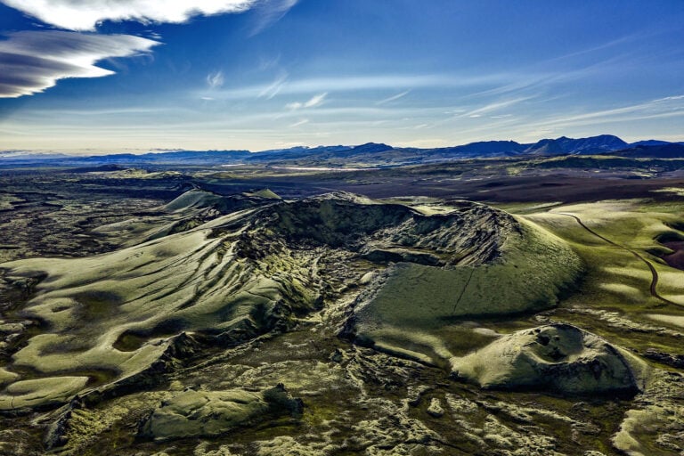
The picture is taken above a series of craters called Lakagígar and ends in a tuff mountain called Laki. It is not known if the craters in the crater series have separate names. But I have been told that locals know what many craters are called. One is called Tjarnargígur, for instance. Lakagígar is a series of craters on a 25 km long eruption fissure west of Vatnajökull Glacier. The series of craters is named after an old tuff mountain called Laki and is close to the middle of the picture. Lakagígar was protected in 1971, but the area was created in Skaftáreldur in 1783-1784, one of the largest eruptions in Icelandic history. Previously, the series of craters was called Eldborgir. The eruption of Lakagígar began on Whit Sunday, June 8, 1783, following a series of earthquakes. Lakagígar lies on ten parallel cracks, each 2-5 km long. At the southern end of the crater series by the Hnúta mountain, the first crack opened. Then started a wave of eruptions that all began with earthquakes. The eruption formed about 135 craters and a 2-500-metre-wide rift valley from the roots of Laki and reached two kilometres southwest of it. Ash and volcanic fumes caused a thick fog and mist over Iceland, spreading over Europe, Asia and America. Heavy pollution accompanied the mist that caused poisoning to the vegetation, so almost half of all livestock perished in Iceland, leading to famine among the people. The mist and eruptions also caused cold weather because they reduced the sun’s radiation and dimmed the sunshine. These were the so-called Mist-hardships, the greatest hardships that have befallen Icelanders. The eruption is one of the most devastating eruptions in human history. The lava from Lakagígar covers about 600 km².